Routekaart:
.jpg)
How to find the refuge
 Since the Middle Ages many pilgrims have traveled along the route from Vézelay, Nevers, Apremont, Jouy and Augy-sur-Aubois.
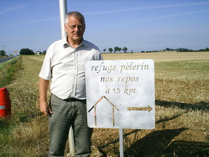
Our refuge is situated along this old route. The GR 654 follows, as far as possible, this antique road trough the nicest landscapes of central France. Take in Apremont-sur-Allier the Direction Sancoins, then follow the Canal du Berry for ± 7 km and turn left And follow the arrows.
Cyclists follow after Apremont the D45/D41 in the direction of Sancoins and then take the D41 (in the direction of Neuilly-en-Dun). About 1 km after Jouy: turn left and follow the arrows.
Our pilgrim refuge is situated 200 meters after the cemetery of Augy Sur Aubois (La Croix).
Distances: Nevers 45 km, Apremont 28 km, Grossouvre 20 km, Sancoins 9 km.
Recommendable guidebooks:
- Topo-guide GR 654
- La voie de Vézelay by François Lepère and André Dehnel.(Éditions Lepère)
Auberge Nos Repos weergeven op een grotere kaart


